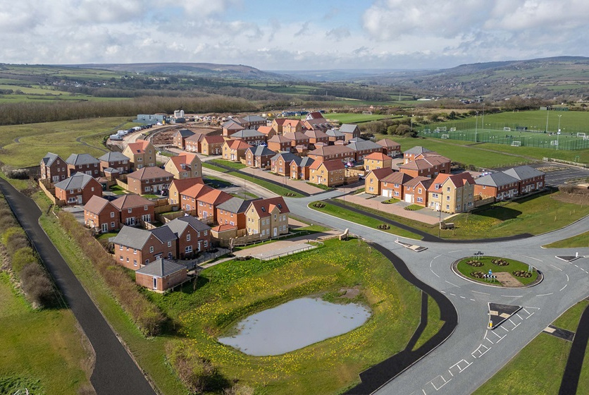
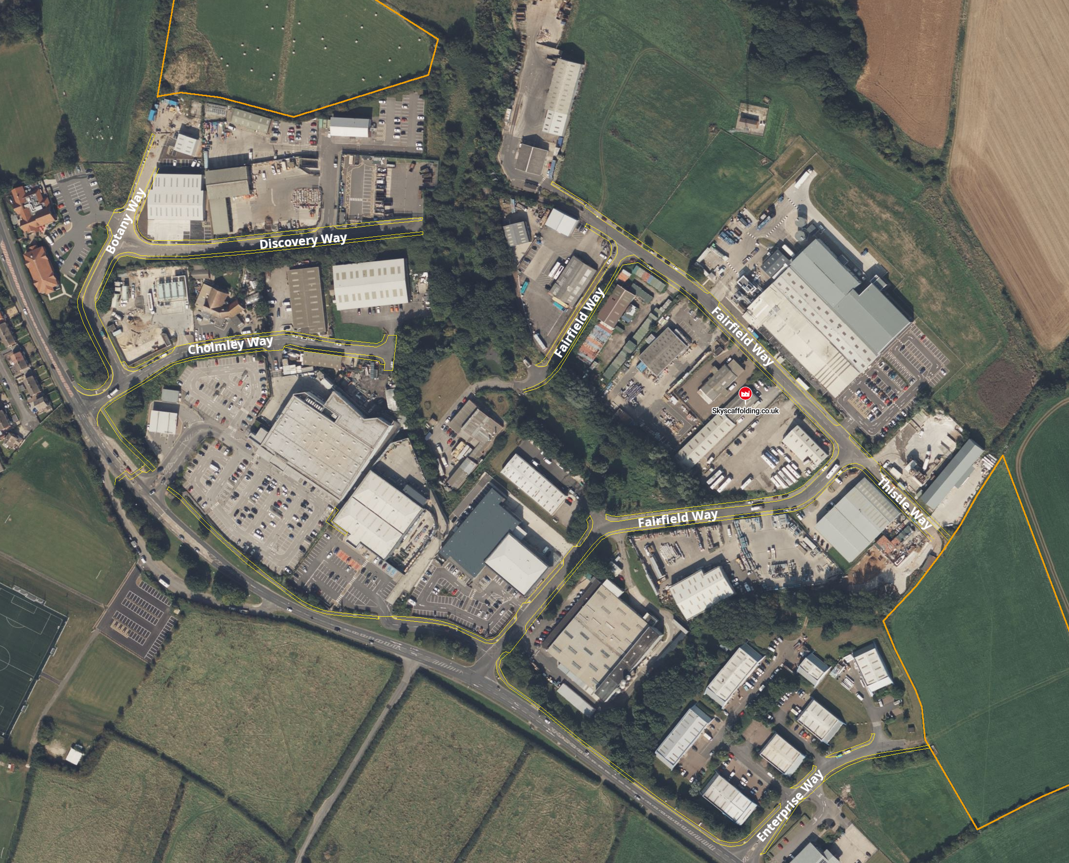
The largest housing estate in the Whitby area in many years is located on east side, bordering the Eskdale Park estate, on the south eastern edge of town. It has to be said that the estate is directly adjacent to the Yorkshire Water sewerage works, and so the aroma may not appeal to some. It is a fact that active travel has to be promoted as a viable means of transport, and that starts in residential areas, where people live. It also needs to be mentioned that whilst Whitby has national average levels of walking, it has amongst the lowest uptake in cycling in the country, largely due to a lack of infrastructure.
What about the provision of active travel infrastructure in this new estate? From the outset we need to say that all previous housing developments in the Whitby area have
- provided footpaths alongside roads, though provision of footpaths away from roads has only been the exception rather than the norm (i.e design for the road rather than for people);
- apported precisely nothing to support cycling;
- typically not provided much in the way of road crossings, with North Yorkshire Council (NYC) seemingly unwilling (or unable, due to funding?) to offer encouragement for pedestrians to get about safely.
Is this development any better for promoting active travel?
As background we have to pay attention to the current (Scarborough Borough Council) Local Plan (2011-2032). The Local Plan, written so many years ago, is a let down in terms of mandating provision of active travel infrastructure. Amongst the few relevant active travel references we have
- Policy INF1 “promoting sustainable modes of transport other than the private car;”
- 5.19 “Applicants will also have to demonstrate that there are safe access and servicing arrangements for vehicles, cycles and pedestrians.”
- 9.12 “To improve the safety of pedestrians and cyclists, the Highways Authority will endeavour, where appropriate, to ensure all new layouts of residential streets restrict vehicle speeds to 20mph. By encouraging people to use more sustainable modes such as walking and cycling for shorter trips and public transport for longer trips, traffic volumes can be reduced significantly and congestion can be avoided. One of the most significant methods for achieving this modal shift is the provision of improved public transport services both through local bus services, or in larger towns, through the provision of cycle facilities at park and ride sites and transport hubs.”
In our assessment, specifically for cycling, we will also make reference to the Department for Transport’s LTN 1/20 (Cycle Infrastructure Design) issued in 2020, which outlines how cycle infrastructure should be provided.
The Estate
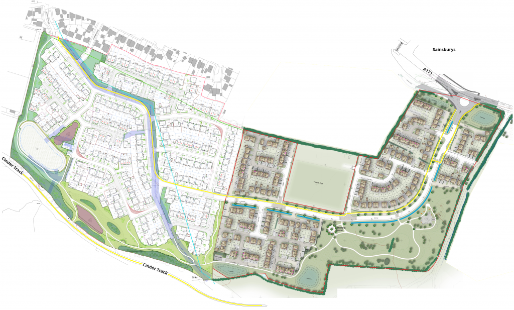
The estate is made up of two parts, Barratts “Abbey View”/ David Wilson “Chaloners Green” (see planning application) to the east of this composite image (providing 233 dwellings), and the Stonebridge development (see planning application) to the west of the image (providing 241 dwellings). It features a spine road stretching from the A171 at the north east (roundabout) to Sandpiper Place (on the Eskdale Park estate) to the north west. It is supposed to eventually provide connectivity for pedestrians and cyclists to the Cinder Track at the south west of this image. It should be noted that this site is in the Local Plan to nominally provide 320 dwellings, not the 474 now approved. Such a “shoehorning in” of homes will clearly have an impact on what is provided along with the dwellings, with less space for green areas / paths (in a town with a large deficit of green space compared to the minimum standard).
In the following diagram, the yellow line represents paths suitable for use by people on bicycles (as well as pedestrians), whereas the white paths are pedestrian only (click on the image for a zoomed in view).
Path Provision - Spine
The main spine road through the estate has a footpath on both sides. The northerly side is a 3m wide multi-use (shared) path, permitting cycling. The southerly side is solely for pedestrians, with the exception of the last maybe 75m which is multi-use (shared). The spine road stretches for approximately 1km (500m for the Barratts / David Wilson development and 500m for the Stonebridge development), from the junction with the A171 near Whitby Business Park through to the junction with Sandpiper Place (at the very north west of the site).
Type of Path
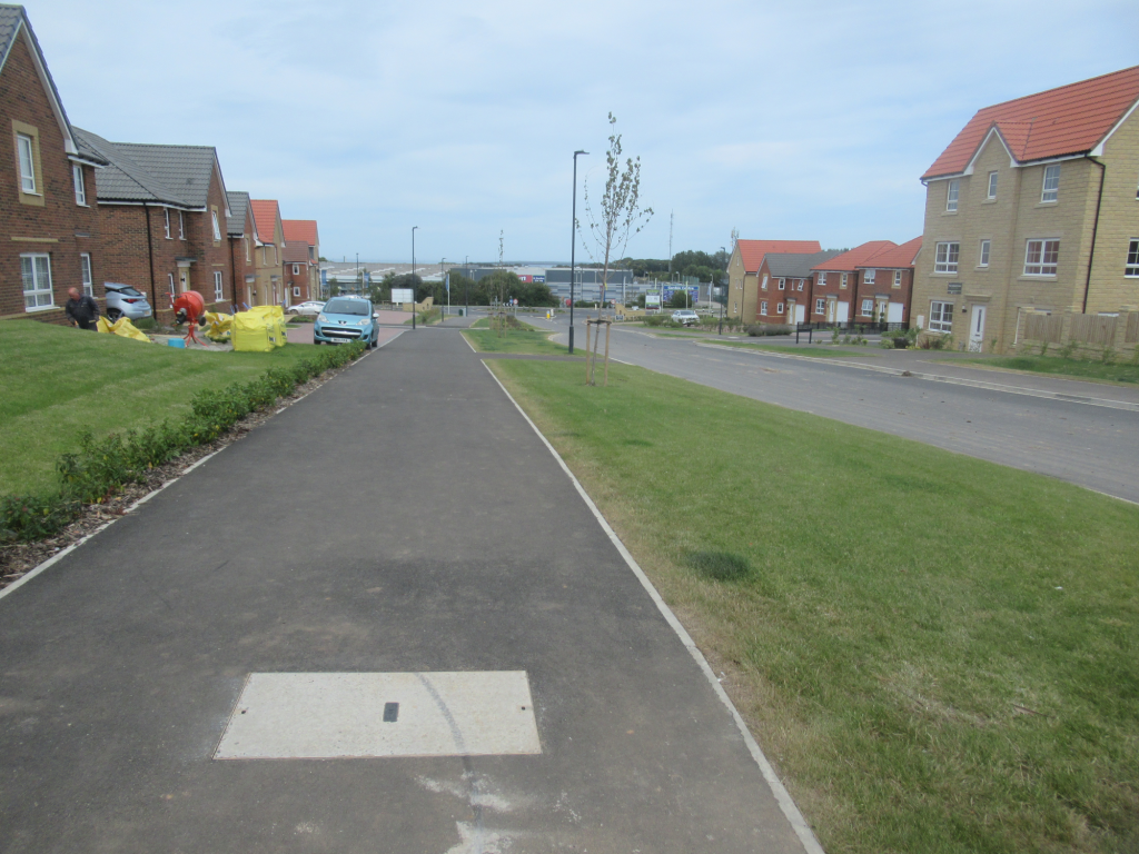
Above we have the multi-use (shared) path on the northerly side of the spine road (at the Barratts / David Wilson side of the estate). Firstly, it has good separation from the road at this location, though the separation from the road for later stretches are not so good. LTN 1/20 states “Shared use routes away from streets may be appropriate in locations such as … paths through housing estates”. It has to be said though, there is ample space for segregated pedestrian and cycling paths, with a dedicated 2-way cycle path. That would reduce conflict between pedestrians and cyclists; and had the developer(s) been permitted to develop just the number of dwellings as specified in the Local Plan then there would have been more than adequate space. As LTN 1/20 also says “Shared use facilities are generally not favoured by either pedestrians or cyclists”. It goes on “Where a shared use facility is being considered, early engagement with relevant interested parties should be undertaken”; this never happened. As a consequence, we would state clearly that segregating cycling from walking, and providing a 2-way dedicated cycle path would have been eminently doable, and would have done more to promote sustainable travel.
In the original outline planning permission NYC Highways did indeed say “Highway Authority further advises that provision should also be made within the internal site layout for a segregated cycle path that runs adjacent to the main spine road and a connection to the Cinder Track”. It seems that this was not heeded, and the developer was allowed to water down the active travel support. Let’s not forget that the NYC Local Transport Plan states “limit traffic growth by reducing the need to travel and developing alternative non-car modes”. The way to develop non-car modes, such as walking and cycling is to make it as viable and conflict free as possible. This requirement has not been followed on this estate, with this shared path more like a grudging token effort.
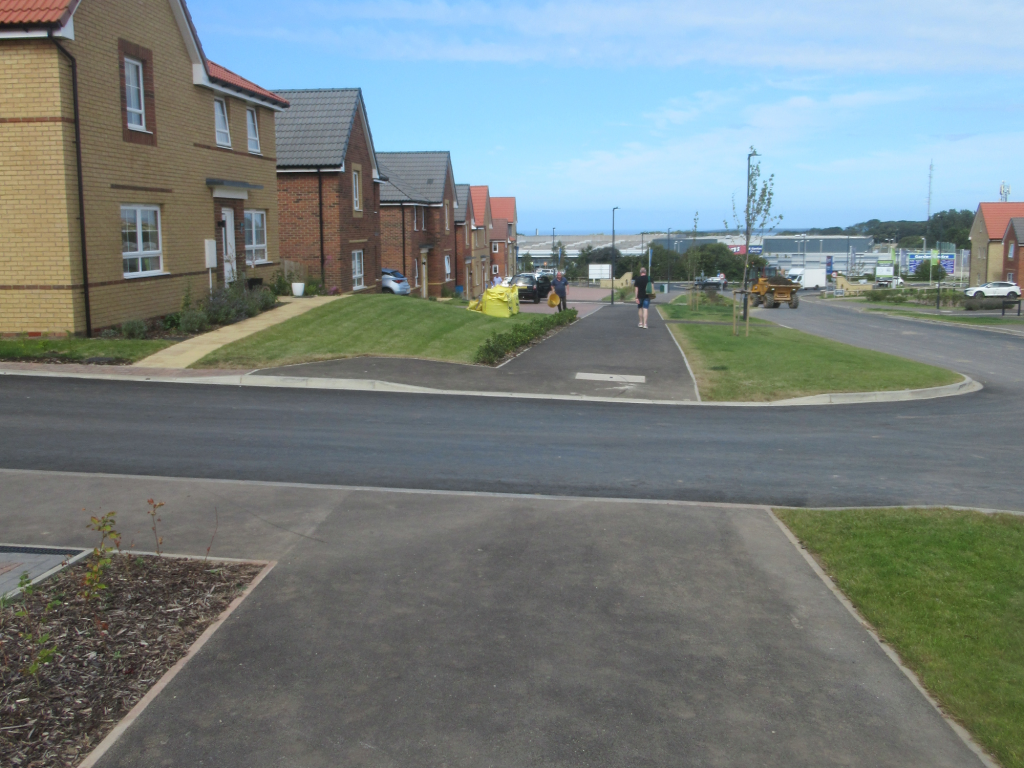
Junction Treatment
The image above shows a typical side road crossing along this spine multi-use (shared) path (at the Barratts / David Wilson end of the estate). In this case there has been no effort to provide a raised path to reinforce any prioritisation for pedestrians and cyclists. Looking at the side road junctions with the multi-use (shared) path across the whole estate we have 9 side roads along its length. Of these we have 5 with raised paths (and raised junctions) and 4 without (i.e as per the photo).
The planning does not specify if there will (eventually) be road markings to define prioritisation for the multi-use path; this is left to NYC Highways to define when they eventually adopt it. Without explicit markings we are left to drivers observance of the current Highway Code which asserts that pedestrians and cyclists have priority when crossing or ready to cross but this is currently badly observed by road users; this road junction design would then lead to pedestrians and people on bikes having to give way most of the time. Explicit “give way” markings such as in Fig 10.16 of LTN 1/20 (see below) are required … we have to wait and see if Highways will do this.
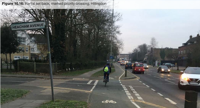
A lack of prioritisation at junctions with side roads would most likely lead to many cyclists not using this path due to the stop-start nature of transit; this would represent a failure of adherence to LTN 1/20.
Similarly use of a raised path on all side road junctions would have reinforced the need to slow down traffic in all side road communities, providing a safer environment for children playing; another opportunity missed.
Given that the estate is only partially constructed, maybe there is still time for NYC and the developers to work together and correct these failings. To quote the NYC Transport Issues and Development Guide when talking about residential schemes “Vehicle speeds should be low and ‘Home Zone’ design principles [link] should be used to give walkers and cyclists a perceived priority”. If residents have to wait for adoption until some potential prioritisation is applied, then this scheme will have failed in its remit in the meantime – the best way to establish habits is to have the environment configured from the outset, not three years down the line.
NYC, when asked to comment, said “The internal road layout has already been agreed with the developer and they have built in accordance with those plans, which do not include at grade priority access for cyclists at the junctions. However with very light traffic flows on the residential side roads, there is unlikely to be significant delays to either pedestrians or cyclists using the path”. Namely that they have no plans to make any intervention, and are seemingly ok with delivery of non-LTN 1/20 compliant infrastructure. This is precisely the reason that NYC’s “capability rating” from Active Travel England is currently 1, the joint lowest of all English councils, and why they have missed out on funding in ATF3 and ATF4 rounds from Active Travel England – infrastructure has to be LTN 1/20 compliant, and this is another example where it is not.
Signage
Whilst it is early to assess the signage being used on this development (given that only the first half of the Barratts / David Wilson side of the estate is built at the time of writing), we can comment on what is present currently.
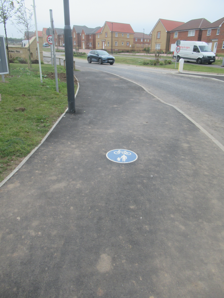
As said above, there are no road markings. What there are though are painted-on shared path markers on the tarmac shared use path.
Path Provision - A171 Junction
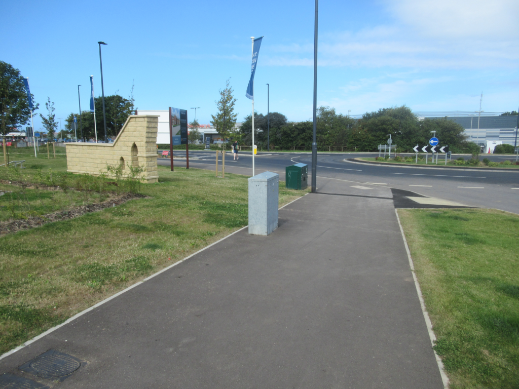
The junction with the A171 is critical to any active travel provision in that it connects pedestrians and cyclists with Whitby Business Park at the other side of the road. The image carousel below shows the three crossings on this roundabout.
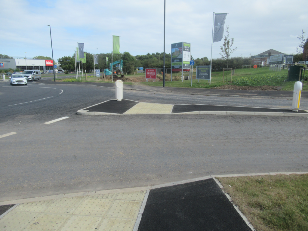
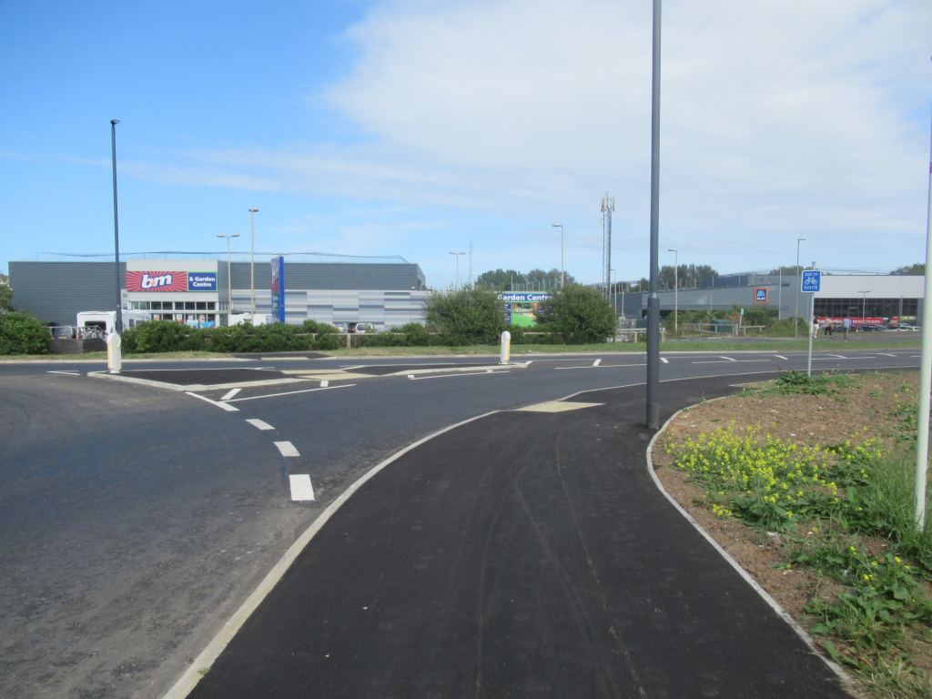
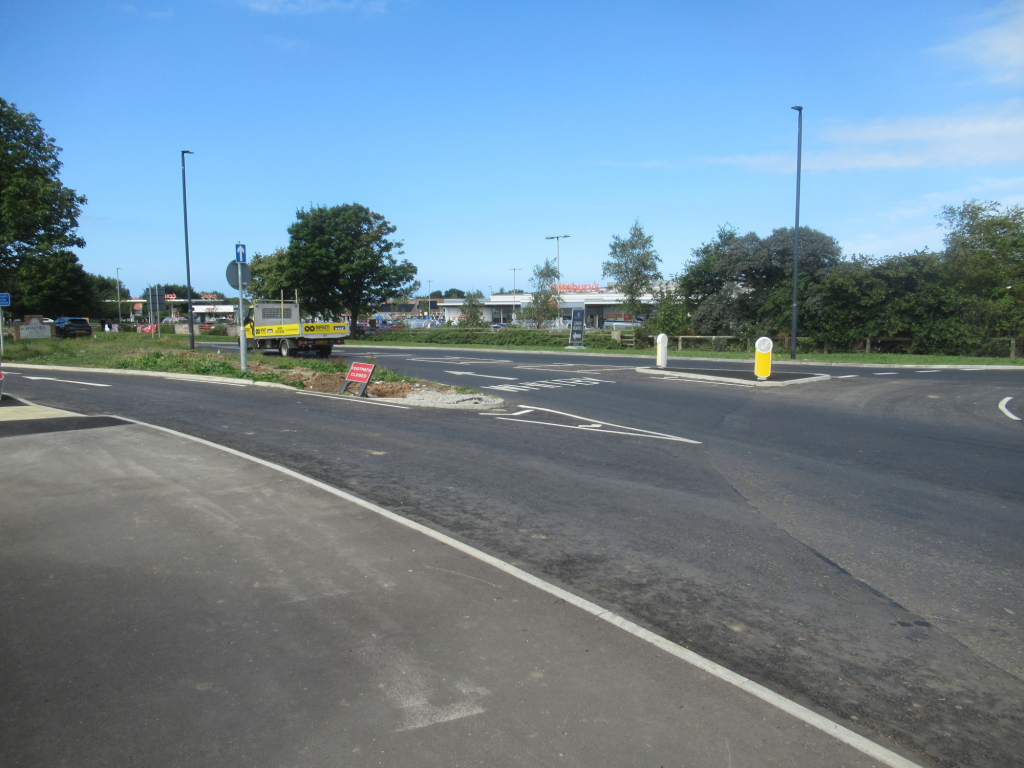
The (uncontrolled) crossing over the estate entry spine road gives no priority to pedestrians – with 474 dwellings this road is likely to have significant traffic at completion. This is a failure to consider the needs of the pedestrian.
The crossing over the estate entry spine road also apports nothing for the cyclist, who is seemingly encouraged to cross this road due to a shared path sign at the other side. As LTN 1/20 states “at higher speeds and traffic volumes uncontrolled crossings are unlikely to meet the needs of all users”. In fact the multi-use (shared) path actually ends once you get across to the other side of the road and approach the (uncontrolled) crossing over the A171 east side. Presumably the idea here is that a cyclist will dismount and walk with their bike? This is a failure to consider the destination of a cyclist, and hence another failure of adherence to LTN 1/20 (one of the core design principles of LTN 1/20 is to allow people to reach their destination).
The 2 (uncontrolled) crossing points over the A171 are similarly for pedestrian only, and give no priority to pedestrians. Whilst the 2022 Highway code changes say that drivers “should” give way to pedestrians wanting to cross, this is largely ignored by motorists, resulting in no priority. The A171 at many times of the day has heavy traffic, and this will lead to pedestrians having to wait for long time periods. This is yet another failure by NYC in pedestrian provision. The pedestrian is faced with crossing over the entry to the layby, and a 50m walk to the sole light-controlled (pedestrian) crossing. The fact that there are no facilities of note for cyclists to either get across the A171, or even to join the road traffic, really does sum up the provision. It would be better to have a parallel crossing for both pedestrians and cyclists (coming off the multi-use (shared) path) and then they could reach the Whitby Business Park safely. The majority of stores on that site have cycle parking, so provide a joined up link.
Considering the 474 dwellings on this estate, which would imply the order of 1000 residents (with the order of 700+ vehicles), and for pedestrians to then have no priority over vehicles in crossing the A171 to get to the shopping area is frankly ludicrous. It will only be a matter of time before the first road collision involving a pedestrian or cyclist at this junction. Maybe NYC Highways have a planned intervention that has not been made public?
NYC Highways were asked to comment on the proposed route for a cyclist to cross the A171 and came back with “the current Barratts development at this site was granted permission five years ago (actually incorrect, it was 3.5 years) and the offsite highway works required were agreed at that time, unfortunately we are not able to go back and ask the developer to provide additional infrastructure, such as a Parallel Crossing as suggested”. So basically there is no route, no plan for a viable route, so you’re on your own cyclists. Note that the Local Plan “promote sustainable modes of transport” existed when this was in planning, as did LTN 1/20 – just that NYC decided to ignore them!
Please note that the planning permission committee report for Barratts / David Wilson development stated “Providing changes are made to the layby and suitable provision is made for pedestrian and cyclists the access arrangements are considered satisfactory”. The problem is that there is currently no suitable provision for pedestrians and cyclists. Additionally it says “it is recommended that widening of existing paths within the highway extents be undertaken where required to achieve minimum widths of 2m for footways and 3m for cyclepaths”. Again, there is no visibility of this provision.
The NYC Transport Issues and Development Guide states “the County Council considers that priority attention should be given to promoting a shift in mode from car to more environmentally friendly forms of transport including public transport, cycling and walking”. Not having any priority for pedestrians to cross the A171 from this large new estate represents a failure to meet this remit. Similarly not having any method for a cyclist crossing the A171 from the estate without having to dismount represents a further failure. These failures negate any positive value of having the multi-use (shared) path.
Path Provision - Sandpiper Place
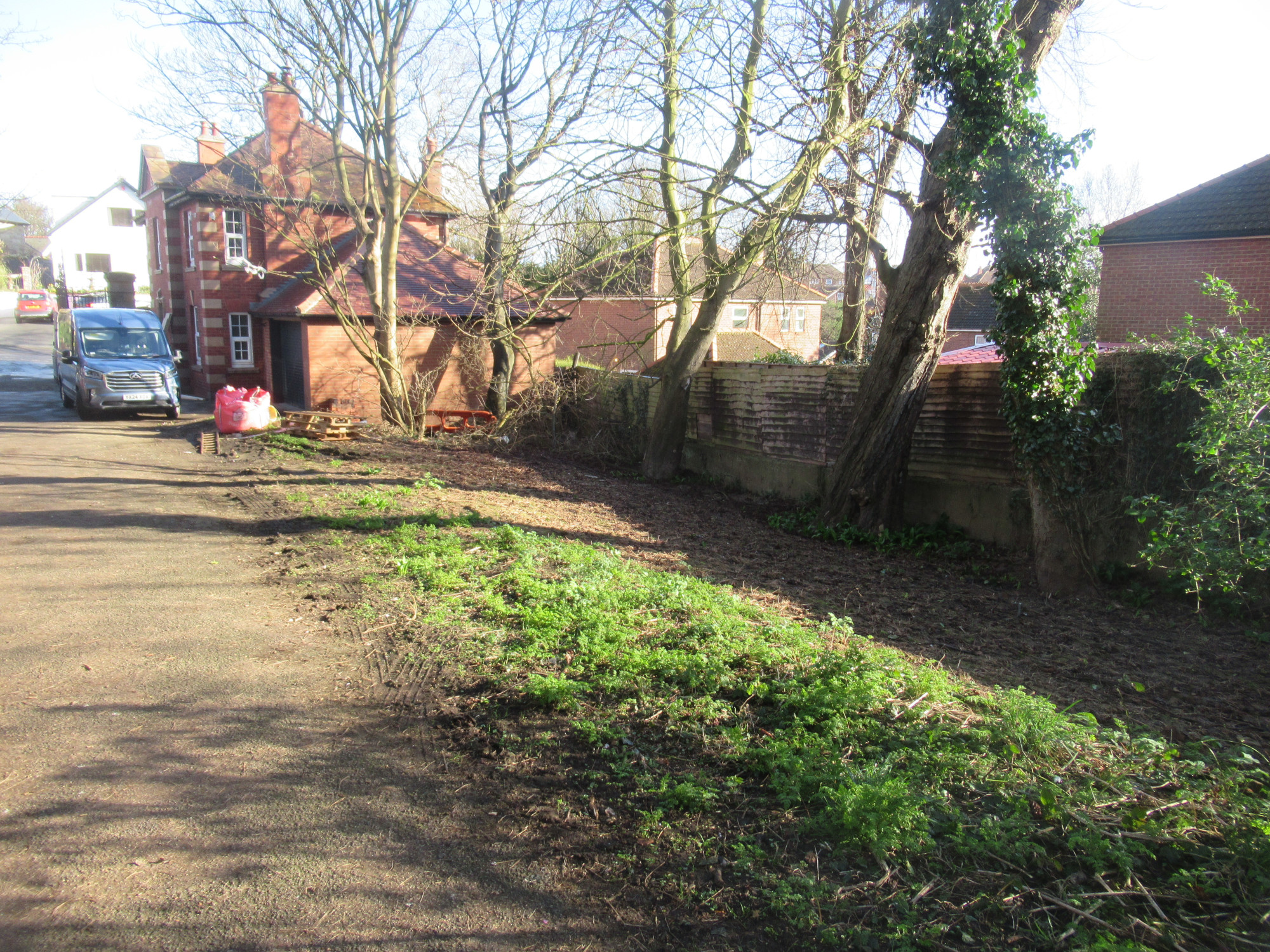
The other junction is where the Broomfield Farm estate reaches Sandpiper Place (on the neighbouring Eskdale Park estate), as shown below.
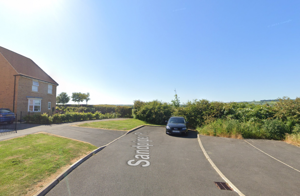
The multi-use (shared) path will simply come to an end. This will need to have associated signage (at the Sandpiper Place side indicating a shared path, and at the Broomfield Farm estate side indicating the end of the shared path), and a way of releasing cycle traffic on to the road (without using the dropped kerb / drive of the last property on Sandpiper Place. The site layout for the Stonebridge development does not show any release path for bikes to get on/off near Sandpiper Place. Something else that will need resolving.
Path Provision - Cinder Track Junction
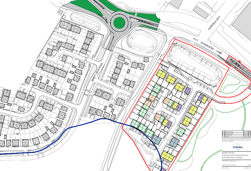
The most significant path in the Whitby area is the Cinder Track (sole piece of cycle infrastructure in the district), which skirts the southern end of this estate. It is essential that the connections between estate and Cinder Track are effective. If we zoom in to that part of the estate
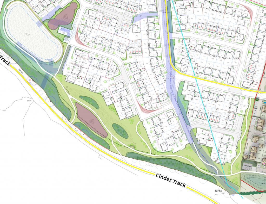
For pedestrians there are several paths that lead to the 2 Cinder Track connections; whilst they may not be particularly direct they do provide the needed connection.
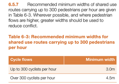
For cyclists, there is no permitted route from the spine multi-use path to the Cinder Track; the paths all seem to be pedestrian footpaths (width 2m or less) and there is no multi-use path (3m width minimum) alongside the adjoining roads. Below is the snippet from LTN 1/20 clearly defining the need for a minimum 3m wide shared path for it to be considered suitable to allow people on bicycles.
This is almost like the provision for cycling was an afterthought. As per LTN 1/20 any route should be direct. Even if we take the route from the corner of the spine path and head south on pedestrian footpaths, cyclists are still faced with 4 sharp bends if wanting to head towards Whitby on the Cinder Track. This is another failure to observe basic cycling infrastructure design. Cyclists will inevitably take short cuts and the green space surface will become eroded, due to the failure to provide a more direct route (and respect LTN 1/20).
Clearly the planning for this part of the estate has only just been passed, and there is time before development for Stonebridge Homes to put this right. This connection should have been designed in from the outset, not addressed as an afterthought!
Stonebridge Homes have been invited to comment on this situation (watch this space if we get a reply).
Evidently not one NYC councillor flagged this issue, but then judging by the utter lack of infrastructure in this district they seemingly have little understanding of the requirements of active travel (and certainly not enough to match the rhetoric in the approved NYC climate strategy).
Estate Paths
The Barratts development provides additional pedestrian paths around the south western “park” area, and along the southern flank of the estate. They provide nothing to the north, so people on the north of the estate are limited to using the path alongside the road – it would have been a simple task of providing some greenspace and a path around the northern boundary.
The Stonebridge development provides additional pedestrian paths along the western edge as well as around the southern flank, joining with the Barratts path, and 2 connections to the Cinder Track. As for the Barratts development, the houses to the north-eastern end of the estate have no path or greenspace on their doorstep. Based on the site layout diagram and the width of the paths (2m or less), they are seemingly only for pedestrians, begging the question how a person on a bicycle would get to the Cinder Track (legally)?
Urban Design Aspects
Whilst it is not the prime focus of this charity, the urban design of a housing development impacts on the propensity to use active travel. Our comments on the urban design of this estate :
- the two developments are designed around the roads, first and foremost, not around people. That said, there are several raised junctions to attempt to calm many of the side roads, which is welcome, and should lead to more opportunities for children to play in roads (which they would have to do due to the lack of green space in the immediate vicinity of many houses);
- the location of the vast majority of “green space” to the south side is primarily for “odour exclusion” purposes (around the sewerage works) and not for provision of quality green space. This means that the housing, in general, will lack any connection with nature, with large swathes of tarmac / block-paving and its associated water run-off. Given the smell, only time will tell whether many residents make use of this space;
- the provision of cycle storage for plots without garages is positive, but that on its own will make no difference to levels of cycling;
- the absence of green space distributed through the development means that there are very few paths connecting different parts of the development – a further sign that this development is designed around the car rather than the person and will likely fail in creating a sense of community.
Conclusions
Our conclusions are as follows :
- this estate provides basic footpaths for pedestrians, but currently (without NYC Highways intervention) fails to give any priority to pedestrians over vehicles and, as such, will do little to encourage more walking. Moreover, significant risk is introduced at the junction with the A171 with no priority crossing point;
- the estate provides a basic 1km multi-use path for use by cyclists, but in its implementation it apparently disregards much of LTN 1/20, treating cycling provision as a box ticking exercise with little consideration for actually making it attractive. There would have been ample space and opportunity to provide a 2-way segregated bike path through the estate, but this opportunity has not been taken and instead opting for cramming in more dwellings with fewer facilities. The junction with the A171 provides no cycle crossing priority (an appalling omission) with the cycle facilities simply ending. There is no connecting path to connect to the Cinder Track for cycling, and neither are the pedestrian paths direct. This does not meet the Local Plan policy of “promoting sustainable modes of transport”. We have to ask, are developers even remotely aware of LTN 1/20?;
- the provision of cycle storage for some dwellings is welcome but, without suitable cycling infrastructure, will make no difference to the appallingly low levels of cycling in this district. Most likely the cycle storage will remain unused, or used for alternative storage, until there is suitable cycle infrastructure around this area. But another box was ticked, so NYC councillors and officers can feel good;
- the estate has no designated public transport connection within easy reach for the ageing population that the town has, and given that the active travel offering in the town leaves much to be desired, this will only increase the reliance on private vehicles. The NYC policy-induced carmaggedon that the town currently suffers from will undoubtedly worsen. Saying that, it is allegedly NYC “policy” to encourage modal shift, only that any action, such as providing a bus service for new estates like this one, is not materialising, rendering the policy a joke.
To summarise, it appears that catering for pedestrians and people on bicycles is more an afterthought than a prime concern, and this development largely fails to realise the potential benefits of active travel and also fails to meet the Local Plan target of “promote sustainable modes of transport”.
As an addendum [Jan 2025], we refer to the NYC “capability self assessment” for Active Travel for 2024 (submitted to Active Travel England), and in response to the question “Do you currently require developers and planning applications to use LTN 1/20?” they answered “Yes”. This is demonstrably false, using the above evidence (as well as examples from other parts of North Yorkshire that we are aware of).
Improvements Required
What could be done to make this estate actually promote sustainable modes of transport?
- Provide a parallel crossing (or similar) on the A171 that feeds straight from the multi-use (shared) path, providing pedestrians and cyclists a safe priority route across the A171.
- Provide “Give Way” markings on all side road junctions with the multi-use (shared) path, so that pedestrians and cyclists have priority.
- Provide an extension of the multi-use (shared) path across to the Cinder Track. This should be seamless, including prioritised crossing of the spine road.
Setting aside the failure to provide a segregated cycle path (which is too late to fix for this development) these are all simple steps really, all readily achievable. Will NYC and developers step up?
We have now (26/02/2025) received a reply from NYC regarding the Stonebridge Homes development, as follows
“As part of the recent S38 technical review and road safety audit for the proposed Stonebridge development adjacent to the Broomfield estate, the perimeter path linking to the Cinder track at the south will be widened from its initial proposal of 2 meters. Additionally, a crossing facility will be provided to allow cyclists and pedestrians to cross from the 3-meter shared-use footway/cycleway and access this link path at its boundary with the Broomfield estate.
The developer of this estate is also proposing a link into the Broomfield estate towards the south, enabling residents to access this link path that connects to the Cinder track. Discussions regarding these proposals are ongoing.”
The Future
From June 2023, Active Travel England is a statutory consultee on all developments of more than 150 dwellings. Sadly that change came too late for the Broomfield Farm estate. It is expected that this change will lead to far greater scrutiny over provision of paths, lighting and connectivity, with much more thought put in to how active travel provision connects with the rest of the infrastructure network. We can only look back and think, if only ?
NYC are in the process of writing a new Local Plan for the whole county which, it is hoped, will provide a much enhanced requirement for active travel, but this is not likely to arrive before 2028. They have climate targets which imply a 900% increase in use of bicycles as form of transport, so this Local Plan (and associated Local Transport Plan) will have to include the implementation of LTN 1/20 concepts for it to match those climate ambitions, otherwise their active travel policy will be even more a laughing stock than it is currently.
Probably the best hope for having future developments with decent active travel support is via the Neighbourhood Plan for Whitby parish. This is being worked up by a steering group led by Whitby Town Council, with representation from the community (including from our charity) to include suitable policies to mandate promotion of active travel, and cycle infrastructure that does take into account LTN 1/20.
Anything is better than what we have currently.

