Infrastructure Plans
With very low levels of cycle infrastructure in the area, alongside many pedestrian paths that are in a poor state of repair, coupled also with some paths being disabled unfriendly, it is essential that this area has a “plan” for moving forward to remedy the obvious problems. Our aim has always been to work towards the infrastructure defined by a Local Cycling Walking Infrastructure Plan (LCWIP) for the Whitby area. This document only defines corridors that require infrastructure development in the immediate Whitby vicinity. Thus we will need to utilise other proposals, as well as work with other bodies such as the North Yorks Moors National Park for the infrastructure required further afield to generate a complete network.
Note : In 2017-2018 the UK Government developed a framework for defining what infrastructure will be required for effective active travel. This utilises a document called a “Local Cycling Walking Infrastructure Plan” (LCWIP). This document is a prerequisite for active travel development funding, and so we urgently needed such a document(s) defining for our area. Whilst North Yorkshire County Council allocated funding for these documents in 2020, all of the funds for the Scarborough Borough Council area was spent on providing the document for Scarborough. Trustees of this charity had to campaign for one to be provided for Whitby.
Infrastructure Prioritisation
One thing we do say regarding relative prioritisation of required routes / paths is as follows. We should start from Whitby and work outwards (impact on the most people possible, and as the majority of the population lives within the town, then paths there will give most benefit).
- For cycling, this means create paths connecting to the Cinder Track first, providing a way of getting to the Cinder Track from all parts of town, and then consider Whitby-Ruswarp, Whitby-Sandsend, and only then think of paths further out (e.g resurfacing bits of the Cinder Track) unless some clear need and associated benefit is defined.
- For walking, this is simpler in that the path network is largely in place (albeit some paths will need improving in quality). Paths currently have little prioritisation over vehicles, so develop alternate routes as well as crossings providing for the main routes that people will walk to go about their daily routine.
Whitby Area LCWIP
A Whitby area Active Travel Plan (LCWIP) was adopted by NYC in May 2025, with the consultees being : Whitby & Esk Valley Active Travel, Walk Wheel & Cycle Trust, North Yorks Moors National Park, and Whitby Town Council. You can read our write up of this document on this link.
The current state of implementation of this plan is shown below. To be specific, the Cinder Track (corridor 6) was constructed in 2021, and the “design” of the Whitby P&R part of corridor 4 was done in 2021/2022 (but concluded that an LTN 1/20 compliant implementation would not be possible – not that this component would be of much benefit to residents, only visitors).
| Corridor | Component | Status | Design Cost (£) | Design Date | Construction Cost (£) | Construction Date |
|---|---|---|---|---|---|---|
| 1a: Whitby Town Centre (DO SOME) | UNSTARTED | |||||
| 1b: Whitby Town Centre (DO MORE) | UNSTARTED | |||||
| 1c: Whitby Town Centre (DO MAX) | UNSTARTED | |||||
| 2: Sandsend to Whitby (North Terrace) | UNSTARTED | |||||
| 3: Sneaton Castle to Whitby Town Centre | UNSTARTED | |||||
| 4: Whitby Park and Ride to Whitby Town Centre | Whitby P&R to Four Lane Ends | DESIGN | 50,000 | 2022 | ||
| 4: Whitby Park and Ride to Whitby Town Centre | Stakesby Vale | DESIGN STARTING | ||||
| 5: Ruswarp to Whitby (with Cinder Track link) | Prospect Hill Line to Whitby | UNSTARTED | ||||
| 5: Ruswarp to Whitby (with Cinder Track link) | Ruswarp Spur | UNSTARTED | ||||
| 6: Stainsacre to Whitby | Cinder Track surface | COMPLETE | 315,000 | 2021 | ||
| 6: Stainsacre to Whitby | Cinder Track access | UNSTARTED | ||||
| 6: Stainsacre to Whitby | Urban area lighting | UNSTARTED | ||||
| 7: Enterprise Way to Whitby | UNSTARTED | |||||
| 8: Larpool Ln to Whitby Town Centre | UNSTARTED | |||||
| 9: Four Lane Ends to Sandsend Rd | UNSTARTED |
North Yorks Moors LCWIP
The North Yorks Moors National Park commissioned an LCWIP from Walk Wheel & Cycle Trust and consultants WSP. The consultees were very wide ranging, covering a large area including surrounding areas such as Teesside. We were invited to participate as a consultee. The consultation started with session #1 (September 2024), covering the ambition of the project, and where it would be desirable to add routes. Session #2 (December 2024) had consideration for the relative prioritisation of the different routes. A summary report (Aug 2025) is provided HERE.
Active Travel Plan Map
The following map highlights existing infrastructure and shows the Whitby Active Travel Plan corridors, together with some other proposals that we have made.
Routes coloured blue are existing facilities. Routes coloured magenta are typical of the routes that would be required to facilitate modal shift towards much more bicycle usage. Routes coloured purple are in addition to the official Whitby Active Travel Plan that we feel are needed to be included. It is important to note that these are not defined routes as yet, just corridors and likely routings.
If this map does not show, click here for a Google Maps version.
The active travel corridors are also downloadable in Keyhole Markup Language (KML) and GeoJSON formats, as follows.
- Corridor 1 (Town Centre) – KML | GeoJSON.
- Corridor 2 (Sandsend – Whitby) – KML | GeoJSON.
- Corridor 3 (Sneaton Castle – Whitby) – KML | GeoJSON.
- Corridor 4 (Whitby West P&R – Whitby) – KML | GeoJSON.
- Corridor 5 (Ruswarp – Whitby) – KML | GeoJSON.
- Corridor 6 (Stainsacre – Whitby) – KML | GeoJSON.
- Corridor 7 (Whitby Business Park – Whitby) – KML | GeoJSON.
- Corridor 9 (Four lane ends – Sandsend Road) – KML | GeoJSON.
- Green Lane Access Route – KML | GeoJSON.
Why Do We Need Cycle Infrastructure ?
There are ample surveys that say that the public perception of roads is that they are simply too dangerous for cycling, see the Dept for Transport stats 2011-2020 showing 66% consider it too dangerous to cycle on roads, see also the recent IPSOS survey in the references showing that 71% support measures to make it easier to walk and cycle more (more people cycling means more people leaving the car at home, hence more space on the road for people using a car … everyone should be in favour if we lived in a logical world). There are significantly more vehicles on the road today (40+million) than in 1990 (23million) and in 1970 (13million), and those vehicles are generally larger and have faster acceleration, so consequently more dangerous for cyclists (and pedestrians). To address the perception of lack of safety on the roads, it is essential that quality safe-cycling facilities are provided, by way of cycle infrastructure to UK Gov LTN 1/20. With particular reference to the lack of cycling highlighted in Whitby, there is little to no infrastructure currently available to overcome the lack of safety for cycling on roads. Consequently, cycle infrastructure should be provided in the Whitby urban area with some urgency, otherwise it will continue to impact on the figures for the Scarborough borough as well as the overall NYC area, not to mention on the physical and mental well-being of local residents.
If we look at what cycle infrastructure is advised for the speed of a road (the figure below, directly from LTN 1/20), for an urban road at 30mph, we cannot simply place cyclists in with general traffic since, as mentioned earlier, the majority of people do not feel safe. Consequently, if we cannot provide cycle infrastructure, due to cost issues, or due to lack of road space, then we need to drop the speed limit to 20mph. This aligns with the 20sPlenty campaign for residential and central areas. This factor effectively guides our strategy. We should aim to have bicycle paths to connect between areas, and have 20mph within areas to provide a level of safety so that a modal shift in transport choice could take place. This strategy also provides the most cost effective way of reaching this point, since providing cycling segregation through residential areas (even if it was possible) would be significantly more expensive than imposing a simple 20mph limit.
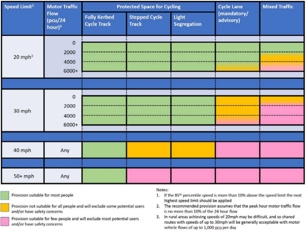
The above image copyright Dept for Transport LTN 1/20.
All drivers of motor vehicles should be fully in favour of segregated cycle infrastructure :-
- A person on a bicycle using a cycle lane means that bicycle is not in front of them on the road causing them to be delayed.
- A person opting to use a bicycle rather than a vehicle means one fewer vehicle in front of them on the road, and one less vehicle competing for a car parking space.
- It also means less pollution and less noise.
Where are the downsides?