Path : Cinder Track
Activity : Walking, Cycling, Wheeling, Scooting, Horse Riding
Difficulty : Moderate
The “Cinder Track” runs along the trackbed of the old Whitby to Scarborough Railway Line. It is now a shared walking path, cycle path and bridleway, and is currently the sole cycle infrastructure in the Whitby area. The “Cinder Track” is on land owned by North Yorkshire Council (NYC), with the exception of Larpool Viaduct which is owned by the Walk Wheel Cycle Trust (via its Railway Bridges Limited subsidiary), and the “Cinder Track” logo image above is © North Yorkshire Council.
You can download the latest NYC-Sustrans CinderTrack leaflet HERE.
The route is shown on the following map (pale blue line), along with bike hire locations (![]() ), bike parking (
), bike parking (![]() ), bike repair stations (
), bike repair stations (![]() ), and some of the hospitality locations close to the track (
), and some of the hospitality locations close to the track (![]() ). Click on the “star”s (
). Click on the “star”s (![]() ) to see an image from each location. Click on the grey “train” symbol (
) to see an image from each location. Click on the grey “train” symbol (![]() ) for a photo of the location during the time of the Whitby-Scarborough Railway. You can select / deselect “layers” to show / hide information.
) for a photo of the location during the time of the Whitby-Scarborough Railway. You can select / deselect “layers” to show / hide information.
If this map does not show, please click here for Google Maps version.
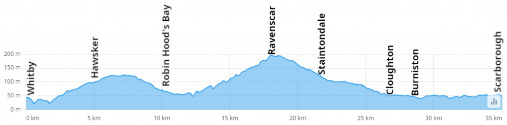
Elevation Profile
Path Status :
- Whitby to Larpool : Leaf residue on the track (slippy), drains not been cleared. Suitable for all activities.
- Larpool – Hawsker : Vegetation encroachment, drains not been cleared. Suitable for all activities.
- Hawsker – Robin Hoods Bay : stretches of the track with loose coarse gravel. Walking, Horse Riding, Cycling (very laborious, not safe for less inexperienced), Wheeling (v difficult), Scooting (v difficult).
- Robin Hoods Bay – Ravenscar : Mudbath (or flooded after any significant rainfall) between Thorpe Lane and Middlewood Lane. Track recently repaired between Middlewood Lane and Fyling Hall station area. Seriously rutted between Stoupe Brow and Ravenscar, with embedded bricks in the track. Walking (muddy, or impassible when flooded), Horse Riding, Cycling (use Middlewood Farm part with caution after rainfall).
Shared Path : cyclists should give precedence to horses and pedestrians; please respect other path users and cyclists please use a bell well in advance and pass at a slower speed. Keep dogs under control. Keep to the left.
Maintenance of the path is the responsibility of the landowner (NYC); you can contact them via their Cinder Track Facebook group, otherwise via their website. Whilst Sustrans has a number of volunteers who help with simple vegetation management and litter picking etc, they are not responsible for day-to-day maintenance of NYC property.
Note (1) : we only cover the section of the track from Whitby to Ravenscar, due to that being the geographical extent of this group’s remit.
Note (2) : You may encounter vehicles on the CinderTrack! As of Sept 2024, NYC have given out 9 licences for vehicular access to the track at Hawsker, Robin Hoods Bay, Ravenscar, Cloughton & Hayburn Wyke. The licence fee from these licences is used to make improvements to the track.
Path Description
Whitby - Robin Hood's Bay
The Cinder Track has a primary point of entry in the Whitby urban area just off Stakesby Vale, alongside the Beevers furniture store. A tarmacced ramp leads up to the track. At the top of the ramp is a Sustrans Millenium Milepost marker.
Warning : this entry ramp is steep, so could be problematic for manual wheelchairs.
Note : the only other safe entry points in the urban area are for able-bodied pedestrians – the entry on Larpool Lane is not considered safe for cycling or wheeling. Use this ramp if coming on a bike or if wheeling.
From the top of the ramp cutting immediately back on yourself, you can reach the top of a bridge with a view on the right hand side up to Whitby Abbey.
Continuing along the track in the direction of Larpool, the surface for this section is tarmac, laid in 2021. Continue under Mayfield Road bridge and you are at a fork in the track (“Prospect Hill Junction”). The path off to the left is where the Prospect Hill Line went, down to Whitby Town Centre; it is an ambition to create an active travel route along this path. The track continues on the left, under a large (currently disused) bridge that was originally a farmers access bridge over the railway line. Follow around a slight dog-leg and you pass “Monkey Bridge Junction” (a wooden footbridge used to sit here over the railway line). The path off to the left heads across Caedmon College Scoresby site playing field to Whitby New Bridge. Head straight on and you are on Larpool Viaduct.
Larpool to Hawsker
This section was surfaced in 2021 with Ultitrec (compacted gravel, made from reconstituted road material). Two small sections were omitted when the surfacing was done (Broomfield Farm to Stainsacre, and the dog-leg at Trailways). Much of this section is either tree lined, or within Stansacre Woods. Consequently be aware of low hanging branches.
After a long straight section you arrive at a ramp down to Stainsacre, with access to the Windmill Inn, and Stainsacre Lane. Cross over the bridge and along a straight section abutted with rear gardens, and pass under a bridge, and the left turn off goes to Summerfield Lane. Continue straight on, and eventually you see 2 railway carriages. This is Trailways, not currently operational, but previously served as accomodation and bike hire. You finally arrive at the A171 with a light-operated crossing to get to the next section.
Hawsker to Robin Hood’s Bay
This section has the original type of surface from the days of the railway, with poor drainage, and surface being washed out is fairly common. After crossing the A171, the section up from Hawsker is very narrow, particularly when vegetation is out of control. The drains on the right hand side (ascending) are of little use on this section as the track is sufficiently deteriorated that it doesn’t drain into them, resulting in frequent washouts of the surface. A gradual ascent continues to Bottoms Lane, which you cross over, and along a section with potholes, past the campervan park.
The track starts to ascend, through Hawsker Sidings (named from the days of the railway), now maintained as a wildflower meadow, with the picnic table. The highest point on this section.
The track starts to descend, and comes around a long sweeping corner with amazing views of the coastline, before arriving in Robin Hoods Bay. On this downhill section there are points where the drains do not serve much purpose due to the deteriorated track not draining into them, surface washouts happen. The track turns on to Cleveland Way, and you arrive on Mount Pleasant North. Cross over the B1447 (Station Road) in to Station Car Park.
Robin Hoods Bay - Ravenscar
Cross through the Station Car Park, and right on to Thorpe Lane for a short stretch, before turning left back on to the track. There is another Sustrans Millenium Milepost.
This section has the worst surface of the whole Cinder Track, with some parts being not much more than boulders where the original surface has been washed away. The section between Thorpe Lane and Middlewood Lane is notoriously bad for mud, with little to no drainage. The section from Middlewood Lane on to Fyling Hall had its surface improved in early 2025. The final ascent to Ravenscar is very bumpy with embedded bricks in the surface.
Arriving in Ravenscar, there is another Sustrans Millenium Milestone just before reaching Raven Hall Road. Continue along Station Road and you arrive at an area with Ravenscar Tearooms etc, and another Sustrans Millenium Milestone.
Development Plan
The Cinder Track was derelict for many years, but in 2017 a study by Sustrans (now Walk Wheel Cycle Trust) defined a possible future for the track as an active travel resource. This was subsequently adapted by Scarborough Borough Council (SBC). Documents for the development are available below, and will be utilised in any future upgrades.
Lighting
The SBC CinderTrack Restoration Plan (2018) included lighting provision between Southend Gardens and Larpool Lane. In 2026 during planning for a round of funding the following was provided by NYC “We had discussions with our street lighting team to understand the likely costs for the proposed lighting along the route. As the route is off‑grid, an electrical supply would need to be taken from Prospect Hill and extended along the full length of the route in both directions. This requires a remote power solution, which is significantly more expensive and has had a major impact on the cost estimate. It would cost more than £500k“