In 2021 funding of £17.1m was allocated to the Whitby Town Deal board for its town improvement plan. This was to provide 6 projects, one of which being an “Eco Village” housing project on the outskirts of the town. This project was initially envisaged to provide 60 affordable eco homes, but was scaled back a little to 49 homes in 2024. The development is to be provided by Brierley Homes, with £2.6m of Town Deal funding, and £2m of North Yorkshire Council (NYC) funding. It should be noted that Brierley Homes is actually owned by NYC; consequently one would expect that this would be the perfect opportunity to demonstrate their capability with provision of active travel infrastructure (rather than relying on the developer to provide it).
In terms of its location, this development is directly alongside the Broomfield Farm estate, that we previously provided an active travel assessment for. In late January 2025 it was entered in to the planning system, allowing us the chance to see how well it will provide for active travel.
As we stated for the Broomfield Farm Estate project, we have to pay attention to the current (Scarborough Borough Council) Local Plan (2011-2032). The Local Plan, written so many years ago, is a let down in terms of mandating provision of active travel infrastructure. Amongst the few relevant active travel references we have
- Policy INF1 “promoting sustainable modes of transport other than the private car;”
- 5.19 “Applicants will also have to demonstrate that there are safe access and servicing arrangements for vehicles, cycles and pedestrians.”
- 9.12 “To improve the safety of pedestrians and cyclists, the Highways Authority will endeavour, where appropriate, to ensure all new layouts of residential streets restrict vehicle speeds to 20mph. By encouraging people to use more sustainable modes such as walking and cycling for shorter trips and public transport for longer trips, traffic volumes can be reduced significantly and congestion can be avoided. One of the most significant methods for achieving this modal shift is the provision of improved public transport services both through local bus services, or in larger towns, through the provision of cycle facilities at park and ride sites and transport hubs.”
In our assessment, specifically for cycling, we will also make reference to the Department for Transport’s LTN 1/20 (Cycle Infrastructure Design) issued in 2020, which outlines how cycle infrastructure should be provided.
The Development
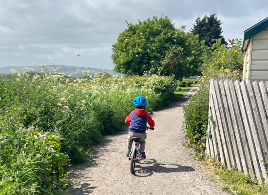
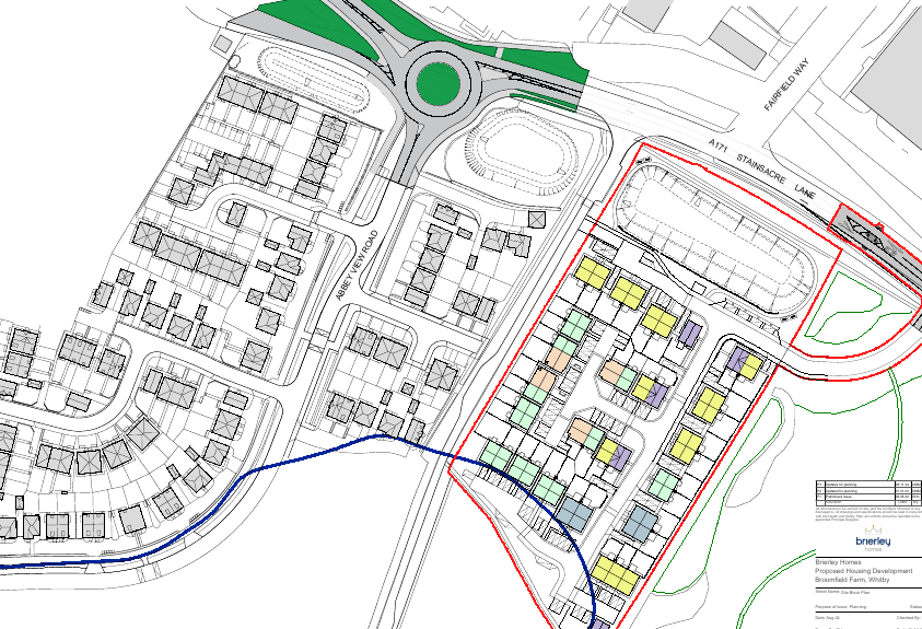
In the following diagram, the solid yellow line represents paths suitable for use by people on bicycles (as well as pedestrians). These are on the previously assessed Broomfield Farm Estate. The dotted lines leading from the yellow solid line are pedestrian footpaths in the planning, but represent the 2 viable routes for shared infrastructure.
Click on the image for a zoomed in view.
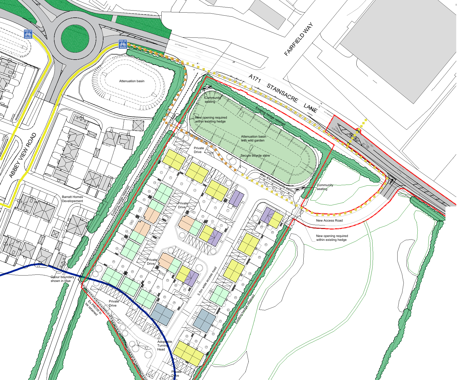
Path Provision
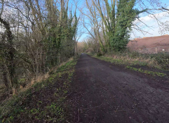
As can be seen from the plan above, the 3m width shared path from the Broomfield Farm Estate ends once it reaches the A171! There are “End of Route” signs for bicycles. The path reverts to a 2m wide path heading east. This width is only suitable for pedestrians (as per LTN 1/20).
Consequently for pedestrians, there is a safe route walking alongside the A171 until the Yorkshire Water / Wildlife Sanctuary side road. Walk maybe 20-30m up this road and there is a 1.5-2.0m wide pedestrian link path to get on to the eco development.
The location plan submitted to planning doesn’t go in to sufficient detail to confirm such as dropped kerbs and tactile pavements at crossings, but NYC’s recent track record on installation of these is not bad, so we assume that adequate provision will be made for wheeling and for blind / partially-sighted.
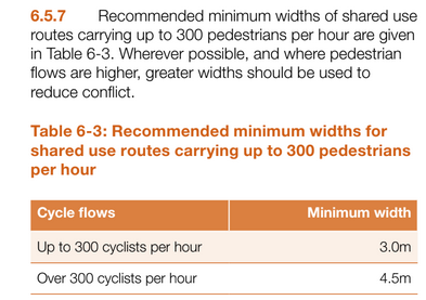
For cyclists, there is a secure cycle storage at the front of the development. This is welcome. Saying that though, there is no defined route to get from the Broomfield Farm Estate shared path to this development. The 2m wide pedestrian path is not wide enough for LTN 1/20 (which requires minimum 3m width). One can only assume that NYC consider it acceptable for a cyclist to have to join the main A171 carriageway, heading east, and then turn in to the development at the new access road. Here is the relevant table from LTN 1/20 for their perusal. It really is very clear when dealing with shared paths.
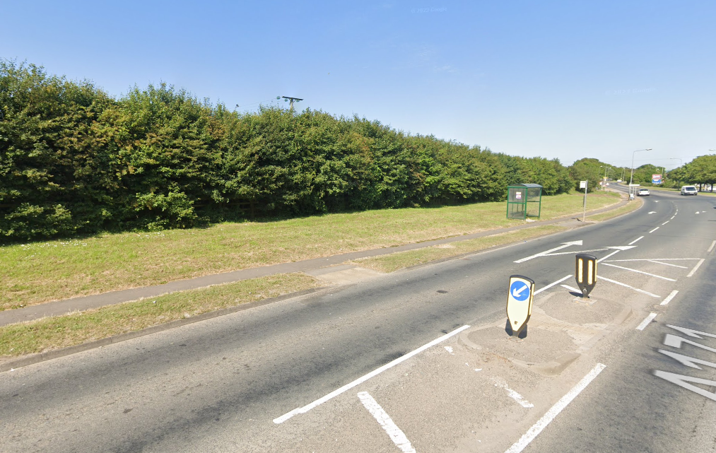
As can be seen from the below photo, there is adequate width for adding a 3m wide shared path with the best location being behind the bus stop to reduce conflict with bus passengers.
Given that the Local Plan requires developments to “promote sustainable modes of transport” this means that they have to make cycling appealing to the majority of people. Given also that LTN 1/20 says very clearly that the majority (around 70%) of people will not cycle on a road. The only conclusion is that this development as currently proposed offers nothing to a person wanting to cycle yet not willing to cycle on the road. If NYC don’t provide a way to get to and from the development, it will only appeal to a minority who are either willing to cycle on the road, or who will (illegally) cycle on the pedestrian footpath. The “eco” credentials of this “eco development” certainly do not originate from catering well for active travel.
Crossing Provision
The other aspect to consider is how to cross the busy A171. This should be a key consideration for the Local Plan “promote sustainable modes of transport”. If a mode of transport has no priority can it be considered to be “promoted“?
In terms of a pedestrian wanting to get to Whitby Business Park, their only options are the uncontrolled crossing (island) at the Broomfield Estate roundabout or, alternatively, the uncontrolled crossing just to the east. Both of these options are unprioritised, and hence, dependent on vehicles. This represents a failure to observe the Local Plan requirements.
In terms of a cyclist, there is no option at all for crossing the road, … other than cycle on the road. Again, this represents a complete failure to observe LTN 1/20 as well as the Local Plan requirements.
On the map we have marked a dotted line where a parallel crossing could be sited. This crossing will be included in the forthcoming Whitby LCWIP for what it’s worth. The photo above shows the location of one of the uncontrolled crossings – this simply needs upgrading to a parallel crossing.
Conclusions
Our conclusions are as follows :
- this development provides basic footpaths for pedestrians, but currently (without NYC Highways intervention) fails to give any priority to pedestrians over vehicles and, as such, will do little to encourage more walking. Moreover, significant risk is introduced at the junction with the A171 with no priority crossing point;
- the development provides secure cycle storage, but no safe and convenient way of reaching the development on a bicycle from the Broomfield Farm estate alongside, nor of crossing the A171 to the business park. This represents a complete failure to observe LTN 1/20.
- the development has easy access to (existing) bus stops on the A171 which will provide access to services to Scarborough, and Whitby town centre – a positive.
To summarise, it appears that catering for pedestrians and people on bicycles is more an afterthought than a prime concern, and this development fails to realise the potential benefits of active travel and also fails to meet the Local Plan target of “promote sustainable modes of transport”.
If we refer to the NYC “capability self assessment” for Active Travel for 2024 (submitted to Active Travel England), in response to the question “Do you currently require developers and planning applications to use LTN 1/20?” NYC answered “Yes”. This is demonstrably false, using the above evidence (as well as examples from other parts of North Yorkshire that we are aware of). This can only be described as disgraceful.
Improvements Required
What could be done to make this development actually promote sustainable modes of transport?
- Provide an extension of the 3m wide multi-use (shared) path from the Broomfield Farm Estate, around alongside the A171 and connect directly to the development (as far as the secure bicycle storage).
- Provide a parallel crossing on the A171, providing pedestrians and cyclists a safe priority route across the A171.
Given that this is currently in the planning system and not yet improved, these are all simple steps really, all readily achievable. Will NYC and (it’s own) developers step up?
We have submitted our findings into the planning system, as well as contacting NYC directly about the failings.
We received a reply from NYC (26/02/2025) as follows
“North Yorkshire Council agrees that establishing a positive connection for pedestrians and cyclists between the Brierley Homes development and the neighbouring Barrett’s development is essential. Currently, the Reserved Matters application for the Brierley Homes site is under review by the Development Management Engineer, and their comments will be available on the planning portal soon.”