Whitby Active Travel Plan
In 2017-2018 the UK Government developed a framework for defining what infrastructure will be required for effective active travel. This utilises a document called a “Local Cycling Walking Infrastructure Plan” (LCWIP). This document is a prerequisite for active travel development funding, and for years Whitby has been deprived of this document with funding used solely for Scarborough. Trustees of this charity had to campaign for one to be provided for Whitby by NYC (using consultants WSP). Our charity was a consultee in the process of creating such this document, and it was finally approved by NYC on Friday 23rd May 2025.
Consultation Process
The consultation process was a 4-step process, as described in the LCWIP document.
- The first session (April 2024) covered the scope, current issues and priorities.
- The second session (June 2024) presented draft walking and cycling network maps (which clearly were before even visiting the town, and with no understanding of viability).
- The third session (September 2024) was the site visit where we showed one of the WSP consultants around various routes by bike, highlighting opportunities as well as routes that were not considered viable.
- The final session (Jan 2025) presented active travel “corridors” and some concept designs of how the infrastructure routes could look.
During session 2 (and afterwards via email) we highlighted many parts of the “draft cycling network map” as well as some parts of the “draft walking network map” that were considered non-viable. These included, but were not limited to, the following
- Primary cycle route along the “Ruswarp Trod Path” which is a narrow walking path including a very steep slope and steep steps!
- Inclusion of Ruswarp Bank B1416 as a secondary route.
- Inclusion of Chubb Hill as a primary route.
- Inclusion of Green Lane as a secondary route.
- Inclusion of Spital Bridge as a primary route.
For the vast majority of these, gradient was the primary issue, and their inclusion must have stemmed from WSP not having visited the area at that point (similar to what we get consistently in planning applications with consultants doing “transport assessments” that do not reflect reality due to not having visited and solely relying on desktop information). This message was reinforced at the site visit, and by the final session consultation these items were not present in the concept designs of the corridors – so WSP had apparently corrected the problems with their draft maps.
Sadly the concept designs were subsequently omitted from the published LCWIP, and with it the “corrections” to the network maps were effectively removed (and so leaving us back with the draft network maps). It is disappointing when, during consultation, feedback is provided, but is then ignored in the final published document – it wastes our time, and it wastes public funds. You can view the concept design document that was consulted (in the final session) on further down this page. If the later phase of presentation of concept design was always intended to be omitted, then the “draft” network maps should still have had the requisite corrections applied during the later consultation phases, otherwise lessons would not have been learnt and a misleading appearance would be put forward (as it is now in the published document). Similarly if the concept designs are indeed of no value to this process then NYC should not have wasted tax payers money on them.
We will not be reproducing the draft network maps since they are not portraying the best representation of the active travel needs here. If they were to be updated to better reflect the feedback provided then we would publish them.
The Corridors Proposed
The “Active Travel Corridors” map is the only map in the document worth referring to due to the aforementioned inclusion of out-of-date walking and cycling network maps.
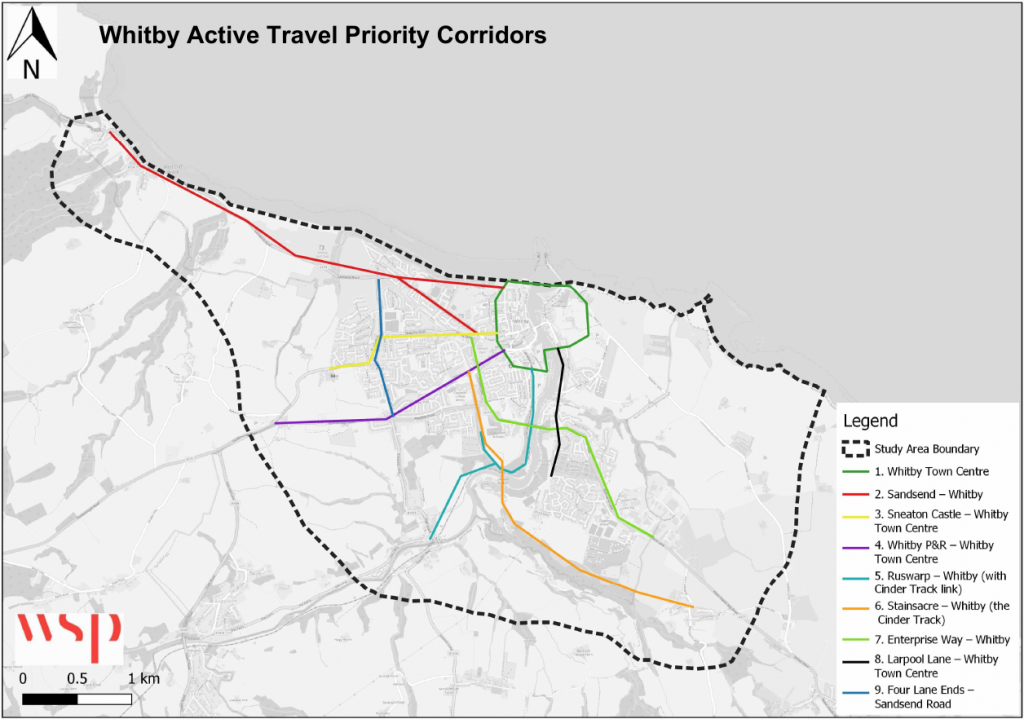
These “corridors” simply provide the primary routes in an approximate sense. In simple terms, we have
- a town centre area that will be handled separately (primarily walking),
- a corridor heading north west along the coast to Sandsend,
- a corridor heading along Stakesby Road / Castle Road,
- a corridor heading along Stakesby Vale and continuing to the Park-and-Ride,
- a corridor heading to Ruswarp and connecting in to the Cinder Track,
- a corridor heading to Stainsacre via the Cinder Track,
- a corridor heading up Helredale Road to the business park,
- a corridor along Larpool Lane, Spital Bridge and Church Street (walking only),
- a corridor from Four Lane Ends to Sandsend Road.
In the main part these corridors make a lot of sense to us. They would result in the majority of parts of the town having a corridor not too distant. Indeed they are not dissimilar to proposals we have made. The main problem we see is the lack of connectivity with Green Lane, particularly for cycling. This point was registered, and given that it was requested at the outset that Green Lane connectivity be considered a priority, then this is a definite omission. Whilst the LCWIP does not now provide such an opportunity, we will continue to look for a way to link to Green Lane area (such as the WCN proposal from 2023).
Corridor Prioritisation
One of the roles of an LCWIP document is to give an idea of relative prioritisation of the different schemes (Stage 5 of the process). Here we reproduce the table from the report. You will note that the description of each corridor does contain information that was embodied in the concept design, so it makes even less sense to omit those.
| Corridor | Improvements | Length | Indic. Cost | Effect. | Policy | Econ. | Deliver. | Total Score | Rank |
|---|---|---|---|---|---|---|---|---|---|
| 1A : Town Centre (Minimum) | New crossings and small interventions focussed on improving the pedestrian experience. | 0.34km2 | £1.23M | 4 | 9 | 5 | 3 | 21 | 1 |
| 1B : Town Centre (Moderate) | As above, but with additional one-way system on Whitby Bridge, footway widening that connect the town centre and a segregated cycleway on North Tce. | 0.34km2 | £3.70M | 4 | 9 | 3 | 2 | 18 | 2 |
| 1C : Town Centre (Maximum) | As above, but further vehicle restrictions on Whitby Bridge from Station Square. | 0.34km2 | £6.41M | 4 | 9 | 3 | 1 | 17 | 5 |
| 2 : Sandsend – Whitby | Upgrade existing footway to shared use path, with two branches following either the Promenade or Upgang Lane. | 3.9km | £4.93M | 4 | 7 | 2 | 2 | 15 | 7 |
| 3 : Sneaton Castle – Whitby | Widening of existing footway on Castle Rd and Stakesby Rd, with new crossings or crossing upgrades at key desire lines. | 2.0km | £2.36M | 4 | 5 | 2 | 1 | 12 | 9 |
| 4 : Whitby P&R – Whitby | 3m wide shared-use path on the south side of Guisborough Rd. New crossings at Four Lane Ends Roundabout and Mayfield Rd, where a shared use path switches to the north side utilising the existing verge. Improved shared-use path on Stakesby Vale. | 2.6km | £3.81M | 4 | 4 | 2 | 3 | 13 | 8 |
| 5 : Ruswarp – Whitby | Upgrading the disused ‘Prospect Hill Line’ to provide a new sealed, shared use path that branches off from the Cinder Track to connect to Whitby harbour and a branch to Ruswarp, including lighting. | 2.1km | £3.88M | 2 | 4 | 2 | 2 | 10 | 10 |
| 6 : Stainsacre – Whitby | Connecting Stainsacre and Whitby via the Cinder Track cycle path, improvements include widening and lighting key connections to the track, re-grading ramps, improving steps and providing a sealed surface to the south of Larpool Viaduct. | 3.3km | £3.98M | 5 | 7 | 3 | 3 | 18 | 2 |
| 7 : Whitby Bus. Park – Whitby | Significant upgrades to the A171 between Prospect Hill and Fairfield Way to create a 3m shared use path, with accompanying crossings and junction improvements. | 2.7km | £4.28M | 5 | 9 | 2 | 2 | 18 | 2 |
| 8 : Larpool – Whitby | Footway improvements on Larpool Lane and Spital Bridge, including widening, dropped kerbs and tactile paving. | 1.3km | £0.91M | 4 | 6 | 5 | 2 | 17 | 5 |
| 9 : Four Lane Ends – Sandsend Road | Providing a crucial link to the north and connecting corridors 2 and 3 requires footway widening to create a shared use path and accompanying crossings. | 1.3km | £1.77M | 4 | 3 | 2 | 1 | 10 | 10 |
Our comments on the rankings assigned in the LCWIP document are as follows
- Corridor 6 (Stainsacre – Whitby) already has a surface, laid in 2021, and is the sole piece of cycle infrastructure in the district. Having a project to dig it up, widen and tarmac it and add lights, should be much lower priority than other paths that do not currently exist (that upgrade in 2021 had consultation in 2017-2018 so why not refer to it?). Does the prioritisation process just count the “benefits” related to upgrading the path? We doubt it.
- Corridor 4 contains an essential path through Stakesby Vale that would facilitate improved cycle to school for Whitby School, as well as a radial route towards town centre for residents, yet it is ranked lower presumably due to being part of a corridor which includes a P&R link. This P&R link would be of minority interest at best – NYC were told this when bidding for it in “ATF2” (but bid they did). Does the prioritisation process not allow different rankings to be assigned to different parts of the “corridor”? Maybe this corridor needs splitting up?
- Having a link to Whitby town centre from the Cinder Track has been stated as being a priority for years (by everyone that uses it), yet the most viable way of doing that for cycling (Corridor 5) is ranked lowest according to the LCWIP. This route, if implemented, would provide a safe route for secondary school children from the Esk Valley to get from railway station to attend Whitby School, and given that it has a 1 in 50 gradient would have the potential to appeal to many people. Why does the prioritisation process not put weight on these factors? One component of the ranking methodology is to use Strava yet, given that this path does not exist as such currently, it will not be ranked favourably using this data!
- All of the corridors that would provide any form of cycle connection to Town Centre are ranked low! One can only assume that the prioritisation process does not add much weight to modal shift and being able to get to/from retail/business/leisure, since a town centre access would be a critical component of that.
- Corridor 7 (along Helredale Road and across New Bridge) is ranked highly, yet there is no subsequent way to get to Whitby town centre if on a bike – so where does the route go and why? Is it to connect to the secondary school? For walking, this route continues to town centre, but how do you allocate the benefit when you are omitting cycling from half of the corridor?
- Corridor 9 (Four Lane Ends to Sandsend Road) is ranked lowest, but would provide an essential component for west side residents to go in the direction of Whitby business park. To facilitate journeys from home to retail outlets by bike, this route would be needed.
If we go back to section 2.3.27 of the LCWIP document, when asked at the outset of the process for priorities from consultees, the items listed were
- The development of a viable route into the town centre.
- Provision of secure cycle parking.
- Improving connections between Green Lane and Whitby, especially cycling infrastructure.
- Establish an off-road cycle route between the Cinder Track and the town centre along the Prospect Hill disused railway line.
- Establishing an off-road cycle route along Upgang Lane greenspace / disused railway line.
- Developing a safe alternative route for NCN 165 between Ruswarp and the town centre.
If you read the LCWIP guidance, they are clearly not aimed specifically at meeting the needs of the people that would use them. Other than the “secure cycle parking“, which could arguably be part of the town centre “corridor”, not one of these consultee priorities feature amongst the highest ranked schemes. So why ask consultees what they want at the outset? One can only conclude that the methodology for determining this ranking lacks some factors important in our locality.
It has to be noted that whilst the LCWIP being adopted by NYC has prioritisation assigned, it does not have the timescales that the guidance (Stage 5) suggests. To facilitate modal shift we need to have cycling viable as a form of transport, to connect residential to key locations, yet with such corridors being consistently ranked lowest, and funding not being provided for active travel, one has to wonder whether this will ever happen in this county.
Corridor Prioritisation Methodology
As we have seen above, the ranking of corridors provided by WSP seemingly fails to capture local factors particular to some of the routes we have outlined. Let’s look at just a few of the factors that NYC are using.
- Effectiveness – this number has one factor being “Strava – Existing active travel demand based on Strava datasets”. On something like Corridor 4 (Stakesby Vale) this will be nil given that the corridor is a greenspace with a traffic regulation order in place. Consequently it will rank lower than it should because of the factor chosen. The same applies to Corridor 5 (Prospect Hill Line). This ranking factor is clearly unable to capture non-existent routes and so is flawed. We would additionally question the use of this data given that the majority of people using this tool would be road cyclists, and modal shift is not typically targetted at such cyclists (and indeed the LCWIP document does say that this data is very limited).
- Policy Alignment – this number includes “Safety – Number of accidents involving pedestrians or cyclists in the previous 5 years within the corridor (500m radius)”. Any off road route will likely have very few issues of this nature since collisions between cyclists and pedestrians are of a less serious nature, and far less frequent. Consequently routes that are away from road are unfairly ranked lower as a result due to a flawed factor. Indeed, Corridors 4 and 5 will be ranked as nil for this as a result.
- Policy Alignment – this number has “Visitor attractions – Does the route improve connections to key visitor attractions?”. So solely concentrating on the impact for the visitor. What about getting to key locations like supermarkets, retail, GPs, hospitals etc for resident and visitor? These are crucial when considering an aim for modal shift. There is no such factor for those.
- Policy Alignment – this number has “Development sites – Scale & proximity of sites with planning permission and/or allocated development sites”. Whilst in general, having new residential near a corridor may help the potential new inhabitants, when you have no little to no infrastructure elsewhere in a locality (like in this town) then using such a factor will unfairly bias towards routes that are for new communities, and against existing communities (which have nothing).
As shown, there are significant weaknesses in the ranking methodology chosen, and each corridor (and indeed, segment of a corridor) should be individually re-assessed before the choice of any such scheme.
Concept Designs
As mentioned above, one phase of the consultation was a presentation of concept designs for each of the corridors, to give an idea of the implementation and how it could look to people affected. Given that this was obtained with tax payers money, we feel it is important that this information is publicly available, and you can view the consultation materials HERE. These are draft concept designs and we did have many comments on them, but at least they give an idea of what an implementation could look like.
Here we will reproduce 4 of the corridor concept designs to give people an idea of what could be provided – please see the link above for full details.
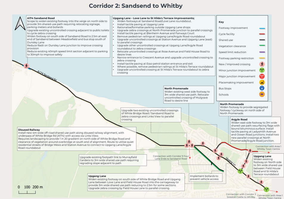
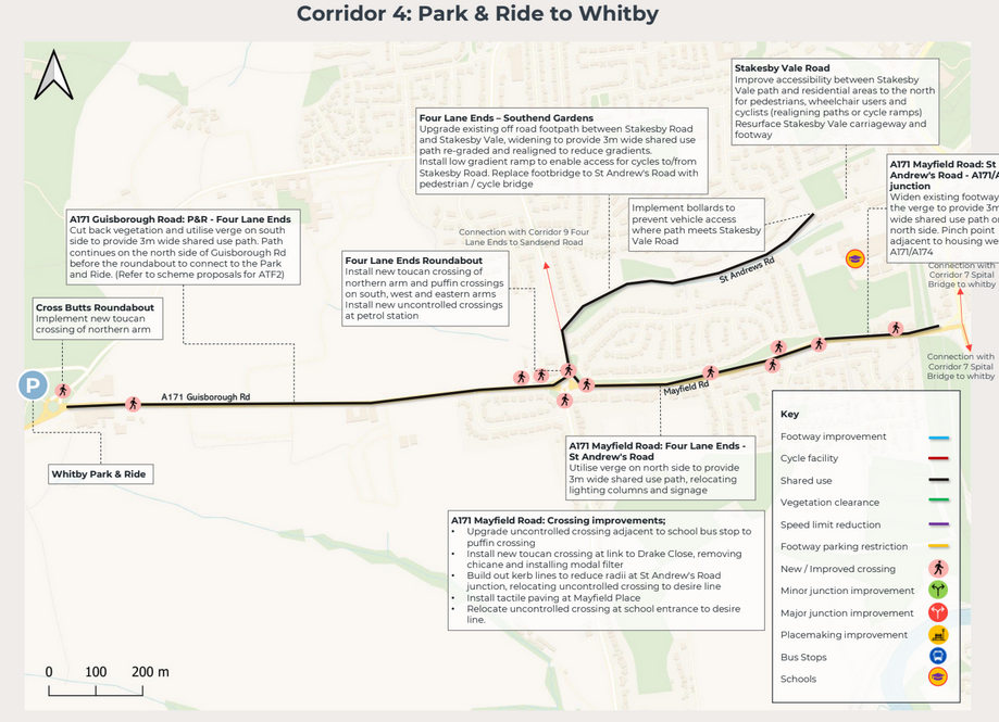
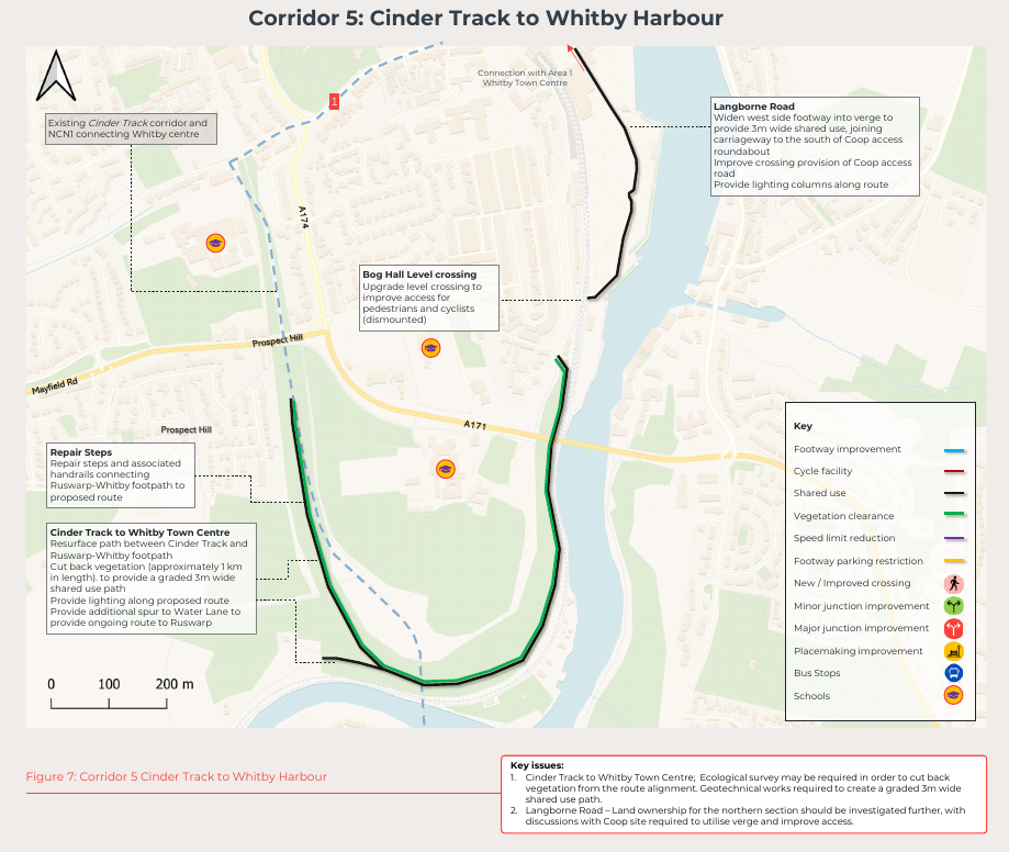
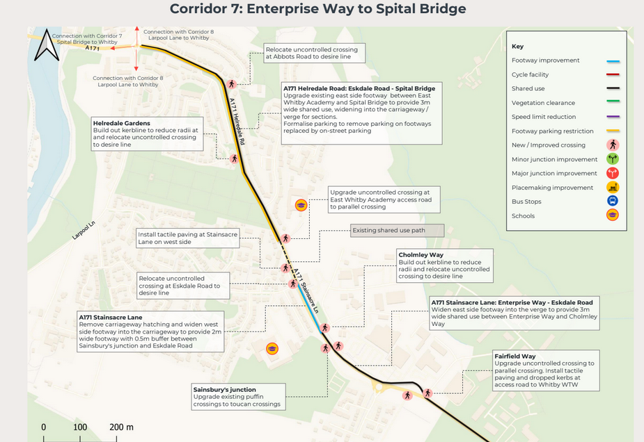
Please bear in mind that these are simply concept designs, not recommendations, to give an idea of the types of deliverables. Any funded scheme will then have to go through a proper design and consultation process, but we feel it important that people visualise what would be possible.